Wolf's Motorhome Modifications
... and Other Stuff
Using Your GPS on the Road
One of the most useful tools you will EVER have when traveling is a GPS-driven mapping program. Nothing will come close to letting you know what to expect when traveling. I use the DeLorme products, both their receiver and their software. There are three basic programs.
Street Atlas
 Street Atlas is the program most often used. It
covers all but the smallest and newest VERY rural locations. As such, it makes an
EXCELLENT tool for exploring a location.
Street Atlas is the program most often used. It
covers all but the smallest and newest VERY rural locations. As such, it makes an
EXCELLENT tool for exploring a location.
But it's major use is when traveling from destination to destination. The first order of business is setting starting and ending points on the map. It will then plot a course for you. You can choose quickest, fewest miles, scenic and a number of other routes. If it picks the wrong route, you draw a box or circle in the area you want it to stay away from and it will route around it. Street Atlas normally picks the best route for a journey.
When underway, the GPS receiver sends data that the map uses to plot your course. If you have set up a route prior to starting, the computer will let you know a short time before each change of course. You can also query the information. The <INS> key will let you know the miles to your next change-of-course, the time, and your speed. The <END> key will let you know the mileage and time to the end of your trip.
I've come to respect both Street Atlas's ability to route and its ability to calculate route times. On the trip I'm on now, I plotted a route from my home in Ohio to the Petrified Forest National Park in Arizona. I determined a thirty hour drive time. I want to drive about ten hours a day. I found the general area that ten hours would be. I now pre-screened campgrounds but found nothing I would want to stay at. I set in information on where the Wal-Marts were. We ended up driving a bit longer but found suitable stops (other Wal-Marts) none-the-less.
Map-N-Go
Map-N-Go is not really as useful to us as it could be. It covers Canada and Mexico, though, and in those ways makes itself needed. It also has exit services and a rudimentary campground locator. It is a nice third source (after Trailer Life and Woodall's). Don't throw out the books just yet, though. Their data is much like that in the AAA books and is of limited usefulness.
Topo-USA
Editions after Version 2 are very useful when checking for trails. It also has the ability to plot your route in 3-D. You can see the mountain, how big it is and what your course through it will be. It lacks the polish of Street Atlas but is essential none-the-less.
Case Studies
Traveling north on I-95 approaching Washington DC, I took the wrong turn onto I-495. This was in HEAVY rush-hour traffic. Normally this could be a critical error resulting in terribly difficult maneuvering. Instead, I brought up the next intersection and zoomed in to see the exit ramps. I observed that I could easily get off, turn left and get turned around. No guessing, no wondering, I knew what I was facing.
We like to explore. We get in the car, turn on the hand-held GPS and take a reading on our current position. We then just wander around. We don't care about getting lost because with the hand-held GPS, you simply follow the arrow home. It a FANTASTIC way to explore!
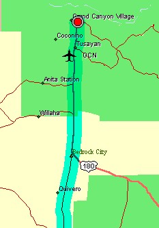
Park trails can be pre-inspected using the features of Topo-USA. Say you want to determine what trails and their difficulty prior to getting to the Grand Canyon. You can see the trail in 3D.
On the Way to A Place
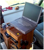 The
lap-top computer is mounted on a box which houses a number of amateur
radio transceivers. A 300 watt inverter powers the power cube of the
laptop. A set of amplified speakers are plugged into the back. (Try
to get a set that use 12 volts DC rather than plugging the speakers into the
inverter. The inverter may introduce noise into the sound.)
The
lap-top computer is mounted on a box which houses a number of amateur
radio transceivers. A 300 watt inverter powers the power cube of the
laptop. A set of amplified speakers are plugged into the back. (Try
to get a set that use 12 volts DC rather than plugging the speakers into the
inverter. The inverter may introduce noise into the sound.)
You won't want to use a screen saver. You should turn those off.
You set the start and finish locations. The program does an excellent job of knowing the appropriate route. Should you have other preferences than those chosen by the program, you can adjust the route.
The GPS receiver is mounted in a compartment above the driver. The cable is routed to the back of the laptop. With a fiberglass roof you won't need an outside antenna. The reciever sees through the fiberglass.
Before each change in course, the computer will alert you to the change. You can see how Interstate intersections are laid out on the map. There's no guessing. You can get the time to the next change of course or the time to end of the trip. The times reported are very close to what they end up being. Direction, altitude, estimated and elapsed times are only a few of the items you will be able to access.
The Computer
You need a laptop that will take the usage you plan for it. I work for an agency that has about 25 mobile laptops most of which are in 24/7 service. We have found that Toshibas, when coupled with their highest warranty option, provide the best service. If you have a problem in the first three years, Toshiba will ship you a replacement and 24 hours later you are back in service (assuming your hard drive was viable and you replaced it into the newer computer). Be sure to get the TOP OF THE LINE warranty option. You probably won't use it. Anything below the top of the line should be reviewed carefully. Our buyer decided to save us some dollars and go with a cheaper policy. We found that "plastic parts" were not covered. The little switch that shuts off the display when the computer is closed is a plastic part. We ate the costs of that repair.
Wouldn't Want To Be Without It
We are far too spoiled to go back to outdated paper maps. These devices so simplify and provide so much real time information that travelling without it is ... like tent camping.
